Wednesday, November 18, 2009

The beaver dam


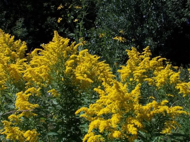
A few times a year, I notice signs of beaver activity on the river bank. Usually, it's a nomadic beaver, stopping only to refuel on the dense willow shoots or elm bark. This river isn't deep enough to support year-round living. This summer, an ambitious beaver decided to change that. I started to see entire trees chewed down, cut to length, and then stuck into the soft river bottom. It was fun to watch the process of dam building, and I found myself amazed at the animal's ingenuity. The dam was well-designed, from its placement next to a big old log for support, to its curving outline that bent with the strongest current instead of fighting it. It was a humble structure at first, but slowly grew under the patient work and eye of its beaver builder. The water level behind the dam rose a few inches over a few weeks. A pond was forming, and large schools of creek minnows swam in the deep pools. The fish attracted herons, and the mink and otter that left tracks telling their story of nighttime activity.

Soon, less friendly human eyes fell upon the dam. A local trapper was contacted by the watershed district and I noticed snares placed over beaver trails on the bank. The trapper's technique was haphazard compared to the beaver's. One evening, as I sat upon the big old log listening to the water cascade over the dam, I actually saw the animal for the first time. It wasn't a large beaver; it was probably out on its own for the first summer of exploration and independent life. The beaver saw me, too. It circled in the water, dunked a few times, then swam under a bank overhang and disappeared (possibly into a den). I was concerned that this beaver, not realizing that it lived in drainage ditch, wouldn't survive the summer because of the tangle of snares set nearby. There aren't a lot of beavers living in this area; goodness knows we could use more wildlife and less sugar beets.

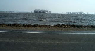
In the end, humans had no say in the matter. An October storm event released several inches of rainfall. The river chose and churned. The beaver dam of sticks and mud flexed and moved, eventually separating and floating downstream in many pieces. The beaver most likely moved on to a place with more stable living conditions. I needn't have concerned myself any more than the watershed district needed to about this animal. The difference is, I hope the beaver returns next year and the drainage advocates do not.

Monday, August 31, 2009

The days of yellow

It is late summer, and the mesic prairie is awash with yellows. Look around and you will see coneflower, wild sunflower, goldenrod, tansy, the dandelion and more all in bloom. The soft sun at twilight only adds to the glow. Soon, other colors will be reflected in the landscape, but for now the days belong to yellow.

Wednesday, August 5, 2009

The dog days


A distinct sound of late summer fills the air, as dog-day cicadas call from the tops of hardwood trees. On the ground, a familiar plant blooms with whorls of flowers that resemble a fireworks display. This plant, common milkweed, was obviously not named by the monarch butterfly. The monarch has adapted over time to use the milkweed for survival. Eggs are placed on the underside of its leaves and the caterpillars are born on their food source. The milkweed contains a toxic substance that monarchs have evolved to tolerate. The caterpillar and butterfly stages carry the substance in their own tissue, making them distasteful to predators. Thus, a plant that grows in "waste areas" like roadsides and sandpits and floodplains, a plant labeled a weed by humans, is vitally important to an insect we find beautiful.

Tuesday, July 7, 2009

The summer low

July and August typically deny our little river of precipitation. It has a relatively small watershed, so the water level is victim the short-term whims of seasonal snowmelt and rainfall (or lack thereof). Currently, the river bed is nearly parched. It's now hard to imagine this little trickle as the seed for a flood. Few fish and even fewer beavers are migrating upstream from the Red River of the North anymore. The water is just too shallow. The conditions are perfect, however, for wading. On a hot day, the sand and silt sparkle under a thin watery lens and provide a cool refuge for bare feet. Chasing minnows, following animal tracks, and collecting smooth stones are all part of summer on the river.

Wednesday, May 6, 2009

The public good

Oakport Township is cleaning up the sandbags and temporary dirt levees and forming a mountain of debris (pictured).  Perhaps they will use this debris in the construction of permanent flood protection.

FEMA officials are visiting with rural residents of the four Minnesota counties designated as disaster areas.  If your home was damaged by the flood, or if you missed work due to the flood, you may be eligible for federal financial assistance.  A professional and friendly FEMA employee from Illinois stopped by our house two days ago.  Help is available to those who need it.  It goes to show that government agencies can do good work if they are run by people who believe in public service.

Monday, April 20, 2009

The continuum


As the floodwaters recede here in the valley, the waters rise out west. West of the Red River Valley is the prairie pothole region. In places like Devils Lake, the standing water level has been rising for over a decade. Birds benefit from it, but cabin owners do not. Farther west, flash floods occur in the steep ravines of the badlands. At least one man fell victim to the Mouse River near Minot.

Back home, things are quiet. We pick up the trash transported downstream from who knows where. There are liquor bottles, beer cans, and blue plastic tarps. Even the strongest flood can't scrub all of this junk away; but we have our share of beauty too. A pair of tundra swans stop by on the way to their namesake breeding grounds. Cormorants dive for minnows in the cold river. The spring air is filled with goose music. Life goes on as it always has, since before humans were here to watch it.

Tuesday, April 7, 2009

The second crest

There will be a second crest on the Red River. There is still a significant snowpack left to melt, and April rains are inevitable. While we wait for the next wave, the receding waters allow us to see what the first wave swallowed. This news comes from the Grand Forks Herald:

Authorities believe a rural Climax, Minn., man found dead in the Red River was swept away in floodwaters as he tried to cross a washed-out stretch of road in a full-size pickup.

Polk County deputies located the body of a drowned man on Sunday evening about 60 yards downstream from where his four-door 2003 Chevrolet Silverado sat up to its windows in about four feet of water, investigator Nathan Rasch said.

Monday, March 30, 2009

The aftermath

A river channel is forever adjusting its path through the landscape, even in the face of man's best attempts to contain it. Our river is no longer wild; it is part of an integrated and efficient farm drainage system. But even this drainage ditch is not static. After every high water event, the current widens the outside bends and scours out deeper pools. Weak banks slough down and trees tumble with them. This most recent flood picked up debris from miles upstream and piled it in the floodplain forest. Corn stalks and cobs, wheat straw, rotten sugar beets, and birch bark collected in mounds wrapped around tree trunks. New ridges of sand and silt lie on the banks, covered in mottled patterns. The new look is only temporary, as the river continues to flow, always changing.

Thursday, March 26, 2009

The cold returns


Roads are closed in all directions, but a morning of 18 degrees (F) allowed us to escape on frozen mud to the post office. The surrounding fields now resemble the Arctic Ocean. The local water levels dropped far enough to open the floodgate on our culvert, draining the icy pond in the yard. But we still wait and watch downstream. Most of our business is conducted in Fargo-Moorhead, and those communities are in a mad dash to keep up with ever-rising crest predictions from the NWS and USGS. Traffic is a mess and some neighborhoods are under evacuation.

Wednesday, March 25, 2009

The crest

Our river crested yesterday, for the first time anyway. It receded almost a foot overnight. Unfortunately, a winter storm blew in and dropped three or four inches of snow before daybreak. Our gravel road is almost passable again, but now the highways are treacherous. Downstream, the Red is still rising. Public officials issue contradictory announcements, calling for more volunteers and advising no travel.

Tuesday, March 24, 2009

The island


It feels strange to hear the birds singing so happily while the river surrounds us with cold brown water. To them, this must be paradise. There is a large flock of geese honking in the body of water that pours over our road. The juncoes are bathing in our yard and picking through last year's sunflowers. Robins hop around the water's edge, occasionally reaching down for something edible. Trees with wet feet have blackbirds in the dry top branches. A red squirrel chatters from the roof of the shed. The county placed roadblocks on both sides of us and most gawkers turn back. It has been quiet and peaceful for most of the island residents today.

The road


The gravel road going north to the highway is under water, and not just a little water. There is a torrent of water, driven by the high winds, eating the road away. It doesn't help that there is a pile of ice chunks and corn stalks jammed up at the bridge, damming the river flow. For the moment, this road is still open to the south. We can probably get out that way. But if we get out, will we make it back in?

Monday, March 23, 2009

The sump pumps


The river creeps higher. If we had any chickens left, they would be sleeping in the willow trees. There is too much water collecting on the wrong side of the flood dike. If the heavy rain hits us, we will need to start pumping it out of the yard and into the swollen river. As it is, the sump pumps have been humming every 15 minutes to keep the basement "dry." Dry is a relative term in these conditions. But everything still works in the house and we still have access to the highway. I wonder what tomorrow will bring?

The rainfall


This is one of Minnesota's new lakes. It used to be a soybean field. The rain started to fall last night. There hasn't been a lot of rain yet, but any rain is bad news. The snowmelt has nowhere to go and the rain will just add to the standing water. Rivers are rising faster now, and local town leaders are pleading with residents to stop using any water appliances. I stopped at a hardware store this morning to get a coupler for our back-up sump pump. A woman there was angry because the sewer drain plugs were sold out. She couldn't find one anywhere. A man suggested that she use a soccer ball or a basketball. The woman stormed out. At the grocery store, people were stocking up on bottled water and soda.

Sunday, March 22, 2009

The slow rise


I opened the floodgate on our culvert last night to drain the pond forming in our front yard. The gate will now remain closed until after the river crests. The river has risen up above the mouth of the culvert this morning and we don't want the water to back up into our yard. The metal machine shed above houses my parents' boat and my canoe. If the need (and river) arises, we can use the boat or the canoe to make our escape. I doubt it will come to that.

For now, the floodwaters can be appreciated for the habitat they are creating for spawning fish and migrating flocks of waterfowl. A pair of wood ducks were dabbling just a stone throw from our bathroom window.

Friday, March 20, 2009

The spring thaw


Today is the first day of spring. This is a time for renewed optimism in the Red River Valley, but it is tempered by caution because the spring melt is also a time for the annual flood. The Red River of the North and every tributary to this great river, large and small, fills up with cold water from the snowdrifts that formed over the past four or five months. Some years, like this one, we also have to consider the rainwater held frozen in the soil from the previous fall.

We live on a small river that feeds the Red. This river serves as the drainage ditch for many square miles of flat farmland. The banks overflow on a regular basis from major rain events, so you can imagine what a record year of snowmelt will do. Our house is surrounded by a tall earthen dike; this structure was built after the big flood of 1997. But the National Weather Service and the USGS suggest that this year's flood could be bigger. This blog is my attempt to document the flood of 2009.